Saturday, 15 January 2011

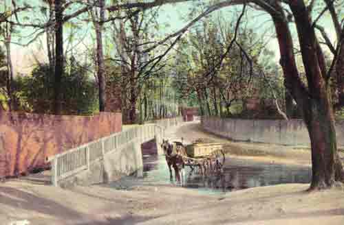
pipistrelle at dead man's bridge


http://www.1900s.org.uk/1900s-edmonton-rural.htm

The famous Pymmes Park Cedar tree was cruelly chopped down to make way for the North Circular Road (A406) widening. The dastardly deed was done overnight, before the protesters could gather in force.

http://www.gigl.org.uk/Partnerdownloads/lbp/RiversOverviewAndSitelist.xls
PCSO Sam Kifford is continuing her Green project in Tile Kiln Lane. Good
progress has been made with the aid of Operation Payback. Fly tipping has
been cleared and a lot of over hanging trees and shrubs have been cut back.

Closure of two cannabis factories in Hereward Gardens, N13. Approximately
200 plants along with electrical equipment were removed from the two
residential properties. An arrest was also made at one of the properties for
cultivating cannabis.

Closure of another brothel in Brownlow Road, N11 and the Clubs and Vice
unit are investigating a female in connection with several brothels which have
been closed down across the Ward over the last couple of months.

Two female Romanian juvenile windscreen washers on the a406 were taken
into protective police custody last week. They were eventually returned to an

-5-

BOWES, SOUTHGATE AND SOUTHGATE GREEN AREA FORUM - 2.9.2010

address in Edmonton. Arrests would be made in the future for public nuisance
should they return.

A prolific shoplifter and known burglar was arrested three weeks ago on
Bowes Road. His property was searched and proceeds from crimes seized at
the property. He has been bailed to return in October whilst victim statements
and CCTV are obtained from the various venues.

Bowes and Southgate Green Wards have a meeting next week with Notting
Hill housing association to discuss the impending squatter evictions on Bowes
Road.

http://boweslabour.blogspot.com/2010/07/pcso-sam-kiffords-fantastic-tile-kiln.html

Sunday, 2 May 2010

بِئْرُالْحُدَيْبِيَّة


Hudaybiyyah Well

Well in which Prophet صلى الله عليه و سلم spat in, this dates back to the time of Prophet صلى الله عليه و سلم and his companions

Mecca Sharif, Saudi Arabia

Screenshot (4497)
Screenshot (4496)
Screenshot (4495)
Screenshot (4494)
Screenshot (4506)
Screenshot (4502)
Screenshot (4503)
Screenshot (4501)
Screenshot (4500)
Screenshot (4499)
Screenshot (4498)
Screenshot (4507)
Screenshot (4505)
Screenshot (4504)

Coordinates: 21.438645, 39.628193

This Well is said to be the place where Prophet Muhammad صلى الله عليه و سلم and his noble companions camped during the historic Treaty of Hudaybiyyah.

Narration from Sahih Bukhari: Narrated by Hazrat Al Bara bin Azib رضي الله عنه:

That they were in the company of Allaah’s Messenger صلى الله عليه و سلم on the day of Al-Hudaibiya and their number was 1400 or more.

They camped at a well and drew its water till it was dried. When they informed Allaah’s Messenger صلى الله عليه و سلم of that, he came and sat over its edge and said, “Bring me a bucket of its water.” When it was brought, he spat and invoked Allah and said, “Leave it for a while.” Then they quenched their thirst and watered their riding animals (from that well) till they departed.

[SahiH Bukhari]

Condition of the well

The depth of the well ranges between 25 and 30 meters, as water is still available to this day, despite its ancient age, and it was affected by sand crawling over seven decades, and the vicinity of the well shows a dome used to collect water around it.

Add comment

Monday, 9 November 2009

Chequers Green - Archaeological Evaluation

http://www.tvas.co.uk/reports/pdf/CQW08_08-12ev.pdf


Trench 13 (Plate 1)
This trench was 20.10m long and 1m deep at the south-eastern end of the trench sloping up to 0.50m at the north-west. The stratigraphy encountered consisted of 0.15-20m topsoil overlying a yellow orange brickearth. At the southern end of the trench an old water channel of post-medieval date (3) was recorded aligned north north east - south south west. This corresponds to a bend in the channel of the Pymmes Brook depicted on the First Edition Ordnance Survey maps of 1866 and 1896 (Fig. 6). Only the northern edge was exposed and thus its true width was not observed, but it was over 5.5m wide. A slot through it showed topsoil , 0.15m, sealing a lens of yellow clay silt deposit 0.20m which overlay a layer of buried soil c. 0.25m deep which in turn sealed a fill of the channel, a pale yellow silty clay (56), which was excavated to a depth of 0.90m and not bottomed at this depth.

Trench 20 (Plate 2)
This trench was 21.10m long and 0.7m deep, orientated south west - north east. The stratigraphy encountered in this trench consisted of 0.5m of topsoil above 0.10m of subsoil over a clayey brickearth. A ditch aligned north east - south west was observed, A slot (2) excavated through it showed it to be shallow, over 1.2m wide but only 0.20m deep, and from its orange grey sandy clay fill (55) a sherd of red glazed post medieval earthenware was retrieved.

Trench 23 (Plate 3)
This trench was 20.56m long and 0.45m deep, orientated south east - north west. The stratigraphy encountered in this trench consisted of 0.5m of topsoil above 0.10m of subsoil over a clayey brickearth. A continuation of ditch 2 was observed aligned north east - south west. A slot (1) excavated through it showed it to be over 1.60m wide and 0.58m deep. It contained three fills (52, 53 and 54) and from its upper fill a light brown silty clay (52) four sherds of creamware, two sherd of pearlware of mid 18th century-early 19th century date and five sherds of red earthenware 1550+, a tin glazed sherd of 17th-19th century date , three clay pipe stems, a sherd of green bottle glass, three iron nails, two tile fragments, wood fragment (non waterlogged) and two burnt flint fragments were retrieved.

Trench 26 (Plate 4)
This trench was 29.0m long and 0.61m deep, orientated south – north. The stratigraphy encountered in this trench consisted of 0.5m of topsoil above 0.10m of subsoil over a clayey brickearth. A ditch aligned north east - south west was observed (4) which was probably the continuation of the ditch 1 and 2 recorded in trenches 20 and 23. This was recorded at 2.80m wide.

Tile Kiln Lane

Sunday, 8 November 2009

The National River Flow Archive

38022 - Pymmes Brook at Edmonton Silver Street

Grid Reference:
51 (TQ) 340
925

Operator:
EA
Local number:
5369

Catchment Area:
42.6 km2
Level of Station:
11.1 mOD
Max. Altitude:
107.0 mOD
Mean flow:
0.48 m3s-1
95% exceedance (Q95):
0.11 m3s-1
10% exceedance (Q10):
0.99 m3s-1
61-90 Av. Ann. Rainfall:
671 mm

Sample Hydrograph of Gauged Daily Flows


Flow Duration Curve for Gauged Daily Flows


Station Description

Crump weir (width: 6.16m) in concrete channel, installed in 1972; superseded a rated trapezoidal section, data from 1954 (rating change in 1963; series reprocessed). Few confirmatory gaugings at high flows. Rarely overtopped. Drowns regularly (c0.7m stage) - flows corrected since 1982; previous high flows under review. Pre-1965 runoff substantially enhanced by sewage effluent (now treated outside catchment). Currently no significant abstractions or discharges.

Catchment Description

Impervious (London Clay) catchment. Pymmes Brook rises on Enfield Chase but catchment is now approx. 60% urban.

Factors Affecting Runoff

  • Natural to within 10% at the 95 percentile flow.

River Flow and Catchment Rainfall on the National River Flow Archive

Gauged Daily Flows (gdf):
1954 to 2006
Monthly Catchment Rainfall (rnf):
1961 to 2006


Datatype
1950s
1960s
1970s
1980s
1990s
2000s
gdf


rnf


For many stations monthly peak flows are also archived. When daily flow data are not available monthly mean flows may be held on the National River Flow Archive. See Data Holdings for further information.

NRFA Home Page
    Station Summaries
    Regional Maps
    Data Holdings

http://www.nerc-wallingford.ac.uk/ih/nrfa/station_summaries/038/022.html 

craft


http://www.topbond.co.uk/hts/pymmes-brook.html

Pymmes Brook


View Pymmes Brook in a larger map