
- Fisher spoke of "the failure of the 21st Century to really arrive" and how in the 21st Century "culture floating free from time"
- This is the stasis that Mark Fisher wrote about in culture as the camouflage which the independents (and yes, the psychogeographers) sometimes use.
With a final push, the landscape turns more marshy through East India, a trolley and several fire extinguishers sitting in the dried mud of the empty dock basin.
- ideas for what Mark Fisher called ‘an alternative modernity’, piercing the neoliberal logic of development which risks defining our recent history”.
- “Witness, for instance, the establishment of settled ‘alternative’ or ‘independent’ cultural zones, which endlessly repeat older gestures of rebellion and contestation as if for the first time.” – Mark Fisher


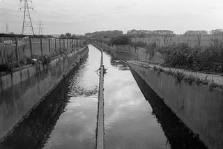
Trinity Buoy Wharf becomes apparent as there are more people and more places, studios using the industrial husks as home. Capital has asserted itself throughout the walk, augmenting everything in its own subtle way, sometimes in manic ways that have lasted for decades – the GMTV yellow hue of the Isle Of Dogs – or recent developments hinted at in New Cross and definitely present further up the Lea at Hope Street. But capital always renders the walker a ghost in the landscape, either attempting to exorcise them, move them along, or render them permanently invisible as the buildings scratch the skyline and the roads become emptied. In visitation, so to speak.


As Mark Fisher writes “Capital is an abstract parasite, an insatiable vampire and zombie maker; but the living flesh it converts into dead labour is ours, and the zombies it makes are us.” Shuffling along the Longplayer Walk, we become spirits in a zone denying any past tense that isn’t suited to the purpose of capital, allowing fleeting waves of nostalgia but only for memories of when we existed but were not really there.


Adam
One thought on “Wanders: Longplayer (New Cross to Trinity Buoy Wharf)”
This time of year it has been a tradition for at least some of my family to get together to go on sometimes fairly lengthy walks, usually somewhere in the country. It’s something that has rather tailed off over the years, with both my sons now having young children, and also as my own legs getting old and tired, making anything over six or seven miles something of an ordeal.

This year things have become even more difficult, with us all under Tier 4 restrictions on travel etc and in different parts of the country, so our meetings have only been virtual. And although Linda and I have managed some short walks – around 5 miles on Boxing Day – these have all started and finished at our home. But at least I can take a digital walk in the Lea Valley.

These pictures were not all taken on the same walk, which is one I did several times when working on my Lea Valley project and have repeated parts of rather more times since, sometimes riding on my Brompton folder. Parts of it have changed dramatically over the years, and wherever in these pictures you see a timber yard, factory or power station there is probably now several blocks of flats.
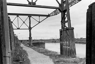
So many changes make it difficult for me to pinpoint the exact locations of some of these pictures, though others have very recognisable landmarks – such as the railway viaduct in the background above, now with a blue plaque celebrating the work of Alliott Verdon Roe, the first man to build and fly an entirely British aeroplane, built here in one of its arches, back in 1909.

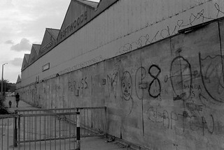
But Latham Timber is long gone, along with its neighbouring yard and the fences on which ‘The Gruesome’ staked their territorial claim and on which P & R pledged their ‘Forever True’ love in white paint on 16-8-82. Where are they now I wonder as I look at these pictures? Though so far as I’m aware I never saw any of them back in 1982 either.


More pictures at River Lea – Lea Navigation 1981-1992. My next post in this series will look a little downstream.
My London Diary : London Photos : Hull : River Lea/Lee Valley : London’s Industrial Heritage : Flickr
All photographs on this and my other sites, unless otherwise stated, are taken by and copyright of Peter Marshall, and are available for reproduction or can be bought as prints.
Towards Hackney Wick 1982
Wednesday, December 30th, 2020I continue my virtual walk downriver towards Hackney Wick.

Past the Clapton Park Estate: Norbury Court, Bakewell Court, Ambergate Court and Sudbury Court at 172 Daubeney Road, each 20 stories with 114 flats, approved by Hackney Council in 1968. Three were demolished by explosions in 1993-5 but Sudbury Court was sold to a private developer who gave it a relatively minor make-over and renamed it Landmark Heights.

Somewhere I passed a canal-side factory –
as well as the wide expanse of Hackney Marshes, with what must surely be more football pitches and anyone needs

as well as some wilder areas where the hogweed grows

and was ambushed by a group of children

close to the River Lea, here looking a very serious river away from the navigation.

My walk continued but in a less linear fashion wandering around Hackney Wick – in the next episode. You can see all the pictures and more in my album River Lea – Lea Navigation 1981-1992.
My London Diary : London Photos : Hull : River Lea/Lee Valley : London’s Industrial Heritage : Flickr
All photographs on this and my other sites, unless otherwise stated, are taken by and copyright of Peter Marshall, and are available for reproduction or can be bought as prints.
Lea Valley 1993 – Around Tottenham Hale
Tuesday, December 29th, 2020

Continuing my pictures from walks along the River Lea and Lea Navigation in 1983 which are in my Flickr album River Lea – Lea Navigation 1981-1992.
Tottenham Hale station on the Victoria Line was a convenient starting point for walks both north and south along the Lea navigatiion, which is crossed by Ferry Lane around 200 metres from the station.
Stonebridge Lock is around 3/4 miles north up the path from Ferry Lane, where steps lead down to the towpath immediately after you cross Pymmes Brook. The view above is looking south back towards Tottenham Hale.
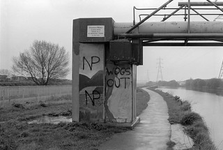
Thames Water Sludge Mains Bridge No 3 crosses the Navigation closer to Ferry Lane, and as well as a crudely painted landscape also carried racist graffiti from the National Party, a splinter group of the National Front which was active from 1976-83.
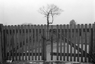
A lone tree behind a gate somewhere on Ferry Lane (or its eastern continuation, Forest Road.)

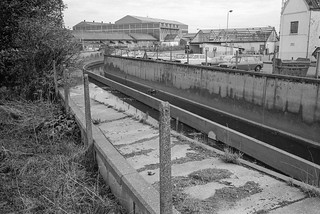
The Lee Flood Relief Channel at Forest Rd. There are now tall recently built blocks of flats replacing the inustrial units and garage in this picture.

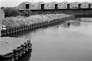
This extensive range of warehouses fronting the navigation immediately south of Ferry Lane has now been demolished and replaced by housing.
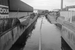
There is a channel here from the River Lee Diversion which takes excess water from the river and navigation north of Enfield, though usually most of the flow in this rejoins the navigation around half a mile further south.

The pattern of waterways it the Lea Valley is difficult to understand and as well as the diversion there are also various flood channels, as well of course as tributaries such as the Pymmes Brook and Dagenham Brook. In the old days there were various man-made channels to feed water mills, while more recently, particularly in the twentieth century various projects to control flooding in the area.
Flickr album River Lea – Lea Navigation 1981-1992.
My London Diary : London Photos : Hull : River Lea/Lee Valley : London’s Industrial Heritage : Flickr
All photographs on this and my other sites, unless otherwise stated, are taken by and copyright of Peter Marshall, and are available for reproduction or can be bought as prints.
Pymmes & Tottenham Marsh 1983
Sunday, December 27th, 2020
The Pymmes Brook is a stream in north London which runs from Barnet and joins the River Lea at Tottenham. It got its name from William Pymme who was given land in Edmonton by Edward II in the fourteenth century.

Although it begins from underground springs at Monken Hadley Common in the London Borough of Barnet, these supply relatively little of the water which reaches the River Lea, particularly when the river is in flood, augmented by water runoff from streets and sewage overflows along with the more normal industrial effluent. Because it used often to flood in its lower course, much is now in deep concrete channels, and in some places is culverted.
I’m no longer sure exactly where I took most of these pictures of the Pymmes Brook, but I think they were just a little after it flowed under the North Circular. I think some may actually be of the Salmons Brook which runs down from Enfield and joins it in Upper Edmonton. This gets its name not from the fish – which were probably once found in it before the area became urban and industrial – but from the 13th century landowner John Salemon.
The river runs more or less parallel to the Lea Navigation just a few yards away across Tottenham Marshes and only finally flows into the Lea close to Ferry Lane in Tottenham Hale.

My pictures of the Lea continue south from Chalk Bridge and past Tottenham Marshes.

On the east side are the large Banbury and Lockwood reservoirs, part of a series up the Lea Valley providing water for much of east London.

This is one of the most picturesque sections of the River Lea, certainly in its lower reaches. I could almost imagine Izaak Walton walking along here in conversation (as Piscator) with his friends Venator and Auceps on May Day holding the discussion of the relative merits of fishing, hunting and fowling as recorded in his ‘The Compleat Angler‘.

More pictures from the Lea in my Flick album River Lea – Lea Navigation 1981-1992
My London Diary : London Photos : Hull : River Lea/Lee Valley : London’s Industrial Heritage : Flickr
All photographs on this and my other sites, unless otherwise stated, are taken by and copyright of Peter Marshall, and are available for reproduction or can be bought as prints.


Really beautiful. made me wobbly to hear Mark Fisher’s voice in your writing….thank you x